
 Continue with onX Maps
 Sign in with Facebook


 Intermediate/Difficult

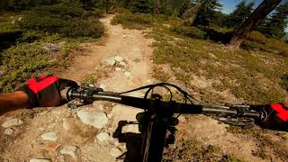
“This trail connects Sugar Pine State Park to McKinney-Rubicon Road (part of the Winter Olympics!). ”


1.4
Miles2.3
KMDoubletrack
 Intermediate/Difficult
Local Club: Tahoe Area Mountain Biking Association (TAMBA)
Land Manager: California State Parks - Sierra District

 Page Meadows Loop
13.2 mi 21.3 km • 1,171' Up 356.84 m Up • 1,171' Down 356.88 m Down

 Sunnysi…, CA

 Antone Meadows loop
8.6 mi 13.8 km • 491' Up 149.79 m Up • 488' Down 148.73 m Down
Dollar…, CA
 Flume Loop
22.3 mi 35.9 km • 2,538' Up 773.56 m Up • 2,540' Down 774.25 m Down
Indian…, NV

 Tahoe Rim: Spooner to Town
17.7 mi 28.5 km • 2,127' Up 648.28 m Up • 2,994' Down 912.68 m Down
Indian…, NV
 Tahoe Rim: Kingsbury Loop
7.1 mi 11.5 km • 1,409' Up 429.45 m Up • 1,409' Down 429.6 m Down
 Tahoe Rim Trail: Brockway to Wilderness Boundary
14.9 mi 24.1 km • 2,457' Up 749.01 m Up • 2,456' Down 748.7 m Down
Tahoe V…, CA


0 Comments