MTB Project Logo

The way up from Roy-L or down to Roy-L.


Your Rating: Rating Rating Rating Rating Rating      Clear Rating
Your Difficulty:
Your Favorites: Add To-Do · Your List

0.1

Miles

0.2

KM

Singletrack

657' 200 m

High

609' 186 m

Low

47' 14 m

Up

0' 0 m

Down

7%

Avg Grade (4°)

10%

Max Grade (6°)

Dogs Leashed

E-Bikes Unknown

Features Drops/Jumps

All trails closed 24 hours after rain.

Description

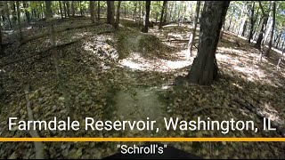
Get your climbing legs on! This trail takes you back to the top of the dam from the bottom. Be careful of a sudden drop in the middle of the trail that can be hard to see if you arent paying attention.

Contacts

Shared By:

Tim McGrath with improvements by Adam Reiman

Trail Ratings

  4.0 from 3 votes

#13691

Overall
  4.0 from 3 votes
5 Star
33%
4 Star
33%
3 Star
33%
2 Star
0%
1 Star
0%
Trail Rankings

#134

in Illinois

#13,691

Overall
1 Views Last Month
46 Since Dec 10, 2016
Intermediate Intermediate

0%
0%
100%
0%
0%
0%

Photos

"Schroll's" MTB ride, west to east
Oct 21, 2025 near East Pe…, IL
"Mike-n-Don's" MTB ride west to east.
Oct 22, 2025 near East Pe…, IL
On the west end
Oct 22, 2025 near East Pe…, IL
Switchbacks
Oct 22, 2025 near East Pe…, IL
Sharp turn!
Jul 22, 2023 near East Pe…, IL
Chunky
Oct 22, 2025 near East Pe…, IL

0 Comments

Weather


Current Trail Conditions

Unknown
Add Your Check-In

Check-Ins

Aug 7, 2023
Jake Dunahee
Jer fell haha 0.1mi
Welcome

Join the Community! It's FREE

Already have an account? Login to close this notice.